

Sectors
Wynfield Innovations harnesses cutting-edge radar technology to provide powerful, dependable, and adaptable sensing solutions for diverse industries. Our products deliver exceptional precision and performance, supplying critical data that enables smarter, safer, and more efficient operations.
Our comprehensive product range addresses a broad spectrum of applications, with each solution designed to meet the unique requirements of its operating environment.
Traffic Management
Traffic Management
Smart highway sensor detects vehicles up to 1000m, monitors 10 lanes, tracks 256 targets for traffic control.

Thoroughfare
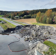
Advanced imaging technologies are critical for enhancing the safety, maintenance, and operational efficiency of modern highways, railways and tunnels against sudden events like cracks, collapses, rockfalls, mudslides or slope displacement.
Border & Perimeter Security

Advanced imaging technologies are critical for enhancing the safety, maintenance, and operational efficiency of modern highways, railways and tunnels against sudden events like cracks, collapses, rockfalls, mudslides or slope displacement.
Hydrology
Non-contact Ka-band millimeter-wave radar technology measures water surface velocity with high precision in rivers and channels. These systems calculate flow speed and discharge without physical water contact.

Parking Facilities

Advanced automated learning technology detects vehicles and pedestrians, preventing gate collisions. Industry-leading performance with lowest power consumption. Ideal for parking and pedestrian entrances.
Fall Detection

This advanced system successfully identifies and monitors various human activities and movements, including the detection of individuals experiencing falls, tracking people's presence within indoor environments, and recognising general motion patterns.
Unmanned Aerial Vehicle

Lightweight solid-state drone sensors provide real-time, all-weather tracking, navigation, and SAR imaging. They detect moving targets like vehicles and people, prevent collisions, and map terrain effectively.
Anti-UAV Systems

These advanced systems integrate LiDAR technology, thermal imaging, and high-resolution video cameras to safeguard critical infrastructure, enhance security at public events, and maintain airspace control. They are engineered to detect and identify potential risks including unauthorised surveillance, contraband transport, and hostile unmanned aerial vehicles.